


Navigation technologies are essential for modern transportation, defense, aviation, maritime operations, and autonomous systems. Two of the most widely used technologies are Inertial Navigation Systems (INS) and Satellite Navigation Systems (SNS), such as GPS. Understanding their differences is crucial for selecting the right system for specific applications.
This article explores the key differences, advantages, and limitations in Comparing Inertial Navigation Systems with Satellite Navigation in practical and technical contexts.
Understanding Inertial Navigation Systems
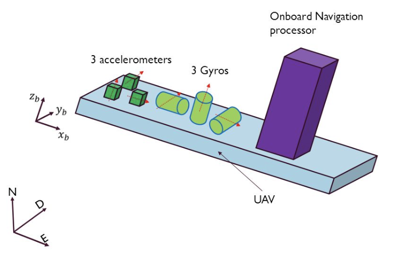
Inertial Navigation Systems (INS) are self-contained navigation systems that calculate position, velocity, and orientation using motion sensors like accelerometers and gyroscopes.
How INS Works
INS operates by continuously measuring acceleration and angular velocity. These measurements are integrated over time to estimate the current position relative to a known starting point.
Key Characteristics of INS
- Does not rely on external signals
- Works in tunnels, underwater, and space
- Provides high-frequency updates
- Suffers from cumulative error (drift) over time
Understanding Satellite Navigation Systems
Satellite Navigation Systems use signals transmitted from satellites orbiting Earth to determine precise location.
How Satellite Navigation Works
Receivers on Earth calculate position by measuring the time it takes for signals from multiple satellites to arrive. With signals from at least four satellites, accurate 3D positioning is possible.
Key Characteristics of Satellite Navigation
- Highly accurate in open environments
- Requires line-of-sight to satellites
- Dependent on satellite infrastructure
- Can be affected by weather, buildings, and signal jamming
Comparing Inertial Navigation Systems with Satellite Navigation: Core Differences
When Comparing Inertial Navigation Systems with Satellite Navigation, the most important differences lie in dependency, accuracy, and reliability.
Dependency on External Signals
- INS: Independent of external signals
- Satellite Navigation: Fully dependent on satellite connectivity
Accuracy Over Time
- INS: Accuracy decreases over time due to drift
- Satellite Navigation: Maintains consistent accuracy with signal availability
Environmental Limitations
- INS: Works in all environments (indoor, underwater, underground)
- Satellite Navigation: Limited in obstructed or enclosed environments
Comparing Inertial Navigation Systems with Satellite Navigation in Real-World Applications
In real-world systems, both technologies are often used together rather than separately.
Aviation and Aerospace
Aircraft and spacecraft use INS for short-term stability and satellite navigation for long-term accuracy. This hybrid approach improves reliability and redundancy.
Autonomous Vehicles
Self-driving cars rely on satellite navigation for mapping and INS for maintaining accurate motion tracking when GPS signals are weak or lost.
Military and Defense
Military systems depend heavily on Comparing Inertial Navigation Systems with Satellite Navigation to ensure uninterrupted navigation in GPS-denied environments.
Advantages and Limitations
Advantages of INS
- Works without external infrastructure
- Resistant to jamming and spoofing
- Highly responsive for dynamic motion tracking
Limitations of INS
- Drift error accumulates over time
- Requires periodic calibration or correction
Advantages of Satellite Navigation
- High long-range accuracy
- Globally available coverage
- Easy integration into consumer devices
Limitations of Satellite Navigation
- Signal blockage in urban or indoor areas
- Vulnerable to interference and spoofing
Integration of INS and Satellite Navigation
Modern navigation systems rarely rely on a single technology. Instead, they combine both systems using sensor fusion techniques.
By continuously blending data from INS and satellite navigation, systems can correct drift errors while maintaining uninterrupted positioning.
This hybrid approach strengthens Comparing Inertial Navigation System with Satellite Navigation by highlighting how they complement each other rather than compete.
Conclusion
Both Inertial Navigation Systems and Satellite Navigation Systems play critical roles in modern positioning technology. While INS offers independence and reliability in challenging environments, satellite navigation provides long-term accuracy and global coverage.
A comprehensive understanding of Comparing Inertial Navigation Systems with Satellite Navigation reveals that the best solutions often combine both technologies to achieve optimal performance, resilience, and precision.
